Global Mapper v26.2 is Released with User-Driven UI & Enhanced Data Visualization Tools
The latest update delivers usability improvements for streamlined GIS workflows, dynamic visualization options, and broader file format support.
In developing Global Mapper 26.2, our priority was clear: efficiency for our users.”
HALLOWELL, ME, UNITED STATES, October 7, 2025 /EINPresswire.com/ -- Blue Marble Geographics® is pleased to announce the release of Global Mapper® v26.2, the latest update to its all-in-one GIS software. This version introduces significant usability improvements, a redesigned animation toolset, expanded lidar and terrain display options, and new support for highly requested file formats.— Jenna Nelson, Training Coordinator
“In developing Global Mapper 26.2, our priority was clear: efficiency for our users,” explains Training Coordinator, Jenna Nelson. “We delved into customer feedback to identify key routines from within the Digitizer menus and made those functions—like quickly obtaining feature measurements and statistics—immediately accessible in the dockable Digitizer Toolkit. I’m excited for new users to find an easier entry point to accessing these functions, and our seasoned users will enjoy how much faster and more intuitive their day-to-day work has become.”
Version 26.2 aligns with Global Mapper’s reputation of flexibility and broad file format support while placing a strong emphasis on user experience. A new dockable file browser provides quick access to directories with options to filter by file type, allowing users to locate the right dataset directly in the application. The Digitizer Toolkit, first introduced in v26.1, has also been expanded to include highly utilized tools for creating path profiles, applying elevations, vertex editing, and displaying feature measurements. Now, users can access all of this functionality from one convenient location. To further streamline workflows, users can now instantly restore toolbar positions with a simple Ctrl + R shortcut, improving layout adjustments for users who work across multiple monitors.
Continuing Global Mapper’s tradition of responding directly to user requests and expanding compatibility with widely used geospatial datasets, the latest release further builds on its extensive file format support including OSM PBF (OpenStreetMap Protocolbuffer Binary Format) and TFADS-O (Table Formatted Aeronautical Data Set–Obstacles). An addition of Phase One’s IIQ image format allows users to import high-resolution RAW images directly, preserving dynamic range and fidelity without the need for conversion to TIFF. This update also includes improved transparency and multiband export options for ECW and JPEG2000, by updating to the latest ECW SDK, further expanding the software’s powerful raster capabilities.
Another major highlight of this release is the redesigned animation toolset. The new Animate Layers button opens a floating pane that simplifies the process of building and managing animations, replacing the previous toolbar with a more powerful and intuitive interface. Users can display layers sequentially to create dynamic visuals such as timelapses, step through timeseries with a slider, record and export animations as videos, and even create multiple animations within a single workspace. It is now easier than ever to transform complex datasets into compelling stories about geographic change over time.
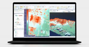
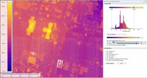
The Lidar/Terrain Display Controls tool further enhances data visualization. Users can now adjust shader color scaling using sliders for terrain data, making it more intuitive to adjust the elevation range and view the results in real time. Pro users can adjust shaders for lidar data as well with an accompanying histogram to show a clear view of the distribution of data for any attribute. Additionally, filtering of point clouds is now made easy, whether the point cloud is lidar or photogrammetric. Filterable attributes are automatically populated, and histogram sliders allow users to interactively adjust which points are visible. Filtered points are not permanently deleted but are excluded from analyses like gridding or contour generation, providing precision and flexibility.
To showcase these updates, Blue Marble Geographics will host a live webinar on October 23, 2025, at 10:00 AM ET, featuring guest speakers from Phase One and Hexagon. This session will provide a guided look at the new tools and demonstrate how they can enhance workflows involving lidar, raster, and high-resolution imagery. Global Mapper v26.2 is available now. For more details or to upgrade, visit: www.bluemarblegeo.com.
Blue Marble Geographics delivers powerful, affordable, and user-friendly geospatial software solutions: Global Mapper Pro®, Global Mapper Mobile®, and the Geographic Calculator®.
Global Mapper Pro supports over 350 file formats and offers an extensive set of advanced tools for terrain analysis, lidar classification, and machine learning-driven object detection. The software’s Pixels to Points® tool enables fast and accurate photogrammetric processing—transforming drone-captured imagery into high-resolution 3D models, point clouds, and seamless orthoimages.
For more than 30 years, Blue Marble’s products have been trusted by government agencies, universities, and Fortune 500 companies worldwide to streamline their geospatial workflows—all within a single, integrated platform. For more information, visit: www.bluemarblegeo.com
Jessica Vachon
Blue Marble Geographics
+1 207-622-4622
email us here
Visit us on social media:
LinkedIn
Instagram
Facebook
YouTube
Other
Legal Disclaimer:
EIN Presswire provides this news content "as is" without warranty of any kind. We do not accept any responsibility or liability for the accuracy, content, images, videos, licenses, completeness, legality, or reliability of the information contained in this article. If you have any complaints or copyright issues related to this article, kindly contact the author above.


